30 Days of Tennessee Archaeology 2016, Day 19
Jared Barrett
TRC Environmental Corporation
Franklin’s Charge is a Tennessee nonprofit corporation dedicated to preserving America’s threatened Civil War battlefields in Williamson County, Tennessee. Part of this preservation effort focused on acquiring the Cotton Gin property along Columbia Avenue with hopes of building a park and building a replica of the Carter’s Cotton Gin, which was near the center of the 1864 Battle of Franklin. However, before they could build the park, they needed to find Carter’s Cotton Gin.
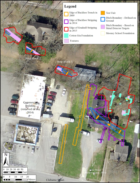
In 2014, Franklin’s Charge contacted TRC Environmental Corporation (TRC) to assist with this effort. In September 2014 and May 2015, TRC staff led by Larry McKee and Jared Barrett picked up where they left off in 2009 and conducted archaeological investigations focused on a search for the precise location of the Carter Hill Cotton Gin and nearby Federal fortification lines associated with the Battle of Franklin (November 30, 1864).
The work was done under contract to Franklin’s Charge, with support from the State of Tennessee Wars Commission and in coordination with the Battle of Franklin Trust. The effort focused on an area south of downtown Franklin in what is recognized as the general location of the cotton gin in an area east of Columbia Pike and north of Cleburne Street. Previous work carried out by TRC in 2009 in this area searched for but did not find remains of this structure or any nearby remnants of the Federal fortification lines. The 2014 and 2015 excavations were guided by the results of the 2009 investigation, along with continued consultations with local experts and documentary sources on the Civil War in Franklin. The 2014 and 2015 investigations were successful in finding and documenting the stone foundations of the cotton gin, along with well-preserved sections of the Federal fortification lines.
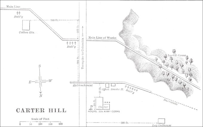
Moscow Carter 1897 map of the Battle of Franklin showing the cotton gin and Federal fortification line (1864).
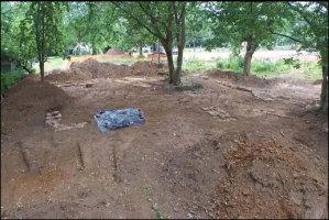
The excavations fully exposed the discontinuous stone foundations of the cotton gin, revealing that its main block measured 41 by 38 feet. The foundations are complicated, showing clear but hard to interpret evidence of several modifications to the facility during its approximate thirty years of use. The foundation was constructed using limestone blocks of varying sizes. No sign of the larger base stone of the cotton press, a separate structure, was found during excavations in 2014 and 2015. The actual location of the cotton gin is 46 feet east of its representation on the well-known 1897 Moscow Carter map of the Federal fortification lines in the area on either side of Columbia Pike.
The stone alignments and clusters defining the location of the cotton gin provide the only reliable data on the cotton gin recovered during the 2015 archaeological investigation. Several pit features found during the work appear to all post-date the demolition of the structure. Only a small number of the artifacts recovered from the excavation actually date to the period when the structure was standing, and none of these shed much light on activities in and around the cotton gin. As discussed earlier, the near total absence of military artifacts recovered from the vicinity of the cotton gin is puzzling, given the structure’s proximity to some of the main fighting during the Battle of Franklin. The stone foundation elements provide strong evidence about the cotton gin but it was disappointing not to have the array of related subsidiary features and artifacts usually found on building sites of this period to help augment the understanding of the structure. Also uncovered during our work in 2014 and 2015 were additional segments of the Federal fortification line.
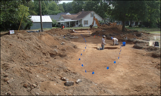
The remnants of the Federal fortification line discovered during the 2014 and 2015 excavations are also to the north and with a more curvilinear route than its representation on the Moscow Carter map. These remains consist of an apparently continuous ditch line of varying depths running east-west approximately 30 feet south of the cotton gin, then curving to the north, just east of the cotton gin, and then straightening out back to an east-west orientation as it extends toward Columbia Pike. Mechanical excavation across the area exposed the top of the ditch in four separate areas. The TRC crew carried out hand excavation of five segments of the ditch feature. Four of these excavated segments yielded a scatter of fired and unfired (“dropped”) small arms ammunition and other military artifacts on the distinct hard-packed floor of the feature, reminiscent of finds within the fortification ditch excavated by TRC on the west side of Columbia Pike in 2009. One segment of the Federal fortification line excavated immediately east of Columbia Avenue recovered a bayonet, ram rod, cartridge case, and dropped ammunition on the floor of the trench feature.
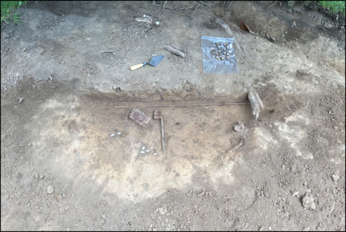
Ram rod, bayonet, cartridge case, and ammunition uncovered at the base of the Federal fortification line east of Columbia Avenue.
There is a notable disparity in the number of Civil War related artifacts recovered from the sections of the ditch excavated south of the cotton gin, and those sections excavated in in 2015, on the Holt property east of Columbia Pike. The relatively low number of artifacts recovered from the excavated sections of the ditch nearer the cotton gin is somewhat puzzling given the ferocity of the fighting known to have taken place during the battle near this area.
The multiple sections of a ditch feature with associated military artifacts discovered during the 2014 and 2015 investigation is clearly a remnant of the Federal fortification lines associated with the Battle of Franklin known to have been in the area south and west of the cotton gin on the east side of Columbia Pike. The excavation results provide clear confirmation of the location and route of the lines along the stretch from the south side of the cotton gin to the east edge of Columbia Pike.
Now that the cotton gin foundation has been uncovered, the plan is to preserve and leave the remaining unexcavated segments of the Federal fortification line. The rest of the area surrounding the cotton gin and Federal fortification line will be used to create the Carter Hill Battlefield Park, with much of the surrounding area left as open space.

